Difference between revisions of "GENIE Gridspec Diagrams Tile"
Jump to navigation
Jump to search
Genie-user (talk | contribs) |
Genie-user (talk | contribs) |
||
| Line 3: | Line 3: | ||
* Cells may be specified explicitly using sub-types of "cell"; the only such type available currently is the [[GENIE:Gridspec:Diagrams:UnstructuredCell|unstructured cell]] type. | * Cells may be specified explicitly using sub-types of "cell"; the only such type available currently is the [[GENIE:Gridspec:Diagrams:UnstructuredCell|unstructured cell]] type. | ||
| − | * Cells may be specified implicitly using a combination of the "regular" and "uniform" properties, and a [[GENIE:Gridspec:Diagrams: | + | * Cells may be specified implicitly using a combination of the "regular" and "uniform" properties, and a [[GENIE:Gridspec:Diagrams:HorizontalCoordSystem|horizontal coordinate system]]. |
| − | Vertical levels are specified separately from the horizontal grid -- currently this is done using a [[GENIE:Gridspec:Diagrams: | + | Vertical levels are specified separately from the horizontal grid -- currently this is done using a [[GENIE:Gridspec:Diagrams:VerticalCoordSystem|vertical coordinate system]]. |
[[Image:tile_type.png|center]] | [[Image:tile_type.png|center]] | ||
Revision as of 15:47, 21 February 2007
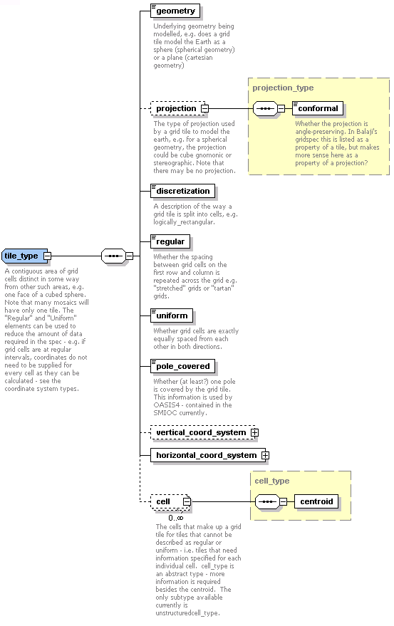
A grid tile is a contiguous area of grid cells distinct in some way from other such areas that together make up a grid mosaic. For instance, a tile may represent one side of cubed sphere, or an independently discretised region of an ocean grid that covers a particular body of water. A grid tile is composed of cells, which may be specified in different ways depending on their degree or regularity or uniformity:
- Cells may be specified explicitly using sub-types of "cell"; the only such type available currently is the unstructured cell type.
- Cells may be specified implicitly using a combination of the "regular" and "uniform" properties, and a horizontal coordinate system.
Vertical levels are specified separately from the horizontal grid -- currently this is done using a vertical coordinate system.
