Difference between revisions of "GENIE Gridspec Diagrams Boundary"
Jump to navigation
Jump to search
Genie-user (talk | contribs) |
Genie-user (talk | contribs) |
||
| Line 1: | Line 1: | ||
| − | Boundary [[GENIE:Gridspec:Diagrams:ContactRegion|contact regions]] occur where two grid [[GENIE:Gridspec:Diagrams:Tile|tiles]] meet, but do not overlap. The boundary type below is suitable for grid tiles with logically-rectangular discretisations; it consists of | + | Boundary [[GENIE:Gridspec:Diagrams:ContactRegion|contact regions]] occur where two grid [[GENIE:Gridspec:Diagrams:Tile|tiles]] meet, but do not overlap. The boundary type below is suitable for grid tiles with logically-rectangular discretisations; it consists of: |
| + | |||
| + | * An anchor point - a point common to both grid tiles; | ||
| + | |||
| + | * An "alignment" flag, used to indicate whether the anchor point is shared in index space by both tiles; | ||
| + | |||
| + | * An orientation, which can be used to indicate how vector fields are transformed as they cross the boundary - for instance, whether latitudes on the first grid tile map to latitudes or longitudes on the second grid tile; | ||
| + | |||
| + | * A refinement, which describes whether grid lines (cell edges) are continuous between tiles, just continuous for the coarser tile, or coprime. | ||
[[Image:boundary_type.png|center]] | [[Image:boundary_type.png|center]] | ||
Revision as of 12:04, 22 February 2007
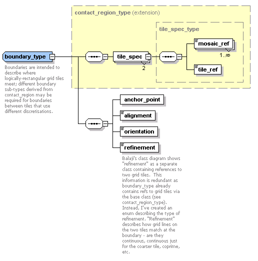
Boundary contact regions occur where two grid tiles meet, but do not overlap. The boundary type below is suitable for grid tiles with logically-rectangular discretisations; it consists of:
- An anchor point - a point common to both grid tiles;
- An "alignment" flag, used to indicate whether the anchor point is shared in index space by both tiles;
- An orientation, which can be used to indicate how vector fields are transformed as they cross the boundary - for instance, whether latitudes on the first grid tile map to latitudes or longitudes on the second grid tile;
- A refinement, which describes whether grid lines (cell edges) are continuous between tiles, just continuous for the coarser tile, or coprime.
