Difference between revisions of "GENIE Gridspec Diagrams HorizontalCoordSystem"
Jump to navigation
Jump to search
Genie-user (talk | contribs) |
Genie-user (talk | contribs) m |
||
| Line 1: | Line 1: | ||
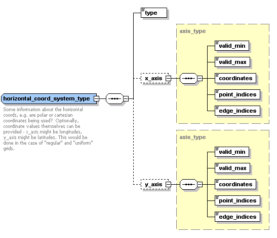
| − | A horizontal coordinate system provides a description of the coordinates used by a grid [[GENIE:Gridspec:Diagrams:Tile|tile]], and may include the coordinates themselves for grids that do not require data at the individual cell level (for instance regular or uniform grids). Coordinates are specified using an "axis" and are encoded in a similar way to the [http://www.unidata.ucar.edu/software/netcdf/ncml/v2.2/AnnotatedSchema.html NcML] "values" element -- either every coordinate can be listed, or a start value and offset given for periodic coordinates. "point_indices" and "edge_indices" are used in a similar way to indicate which coordinates refer to cell edges, and which to grid points. | + | A horizontal coordinate system provides a description of the horizontal coordinates used by a grid [[GENIE:Gridspec:Diagrams:Tile|tile]], and may include the coordinates themselves for grids that do not require data at the individual cell level (for instance regular or uniform grids). Coordinates are specified using an "axis" and are encoded in a similar way to the [http://www.unidata.ucar.edu/software/netcdf/ncml/v2.2/AnnotatedSchema.html NcML] "values" element -- either every coordinate can be listed, or a start value and offset given for periodic coordinates. "point_indices" and "edge_indices" are used in a similar way to indicate which coordinates refer to cell edges, and which to grid points. |
Horizontal coordinate system "type" can currently be "polar" or "cartesian", but this is readily extensible. | Horizontal coordinate system "type" can currently be "polar" or "cartesian", but this is readily extensible. | ||
[[Image:horizontal_coord_system.png|center]] | [[Image:horizontal_coord_system.png|center]] | ||
Revision as of 16:16, 21 February 2007
A horizontal coordinate system provides a description of the horizontal coordinates used by a grid tile, and may include the coordinates themselves for grids that do not require data at the individual cell level (for instance regular or uniform grids). Coordinates are specified using an "axis" and are encoded in a similar way to the NcML "values" element -- either every coordinate can be listed, or a start value and offset given for periodic coordinates. "point_indices" and "edge_indices" are used in a similar way to indicate which coordinates refer to cell edges, and which to grid points.
Horizontal coordinate system "type" can currently be "polar" or "cartesian", but this is readily extensible.
